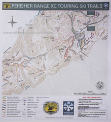
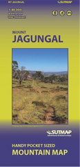
Printed on waterproof tyvek this tough map covers the Snowy Mountains Main Range on one side at 1:25,000 & Guthega to Round Mountain including Mt Jagungal on the other at 1:50,000 with amazing detailed representation with 10m contour intervals. Also with detailed insets of Watsons Crags, Dead Horse Gap, Blue Lk, Lady Northcote Canyon & marginal info a plenty.
This topographic map of the N.S.W. Alpine Main Range and Jagungal Wilderness covers the highest mountains in Australia. It was born from the need for a detailed and durable map of the Snowy Mountains to understand and navigate this unique landscape. It is inspired by the beautifully illustrated Skitourenkarte of Switzerland and the modernist style of U.S. Geological Survey maps of the 1960’s.
Great maps are both beautiful and functional. This map is based on a digital elevation model which provides a detailed and accurate spatial understanding of peaks, valleys, lakes, rivers and other geographic features. Relief hillshading allows the terrain to ‘pop’ from the surface enabling easy perception of natural landforms. Key features include:
- 10m contour intervals (in contrast to 20m standard)
- 1:25k map of the Main Range and 1:50k map of Jagungal Wilderness
- Detailed insets of Watsons Crags, Lady Northcote Canyon, Blue Lake and Dead Horse Gap
- Information for all pursuits such as hiking, climbing, skiing and biking
- Sidebar information on navigation, huts and more
The A1 double sided map is built for adventures in every season. The map is printed on Tyvek® which is a textured ‘paperlike’ material that withstands tempestuous winter weather. It is specially folded for quick and easy navigation in high winds and is also lightweight.
- Printed on Tyvek® which is resistant to tearing, water, snow, mildew, staining, UV, chemicals and is also recyclable
- Tyvek® is sometimes used as a groundsheet and is often useful in emergency situations
- Inks are colourfast, waterproof, UV resistant and have been carefully selected to ensure legibility in poor visibility weather
- Double sided A1 when fully unfolded
- A5 folded size to fit in jacket pocket
- Concertina fold pattern enables quick and efficient opening
- Lightweight at approximately 125 grams
Not all maps are made equal. Not only is the detail on the map superior to the current NSW Spatial Services maps (2017) it covers the equivalent of several Spatial Services maps thereby removing the need to purchase and carry multiple maps. Many new and existing features have been added and checked such as:
- New Spencers Creek Bridge
- New segment of walking track from Guthega to Charlotte Pass (Iconic track)
- New toilets at Seamans Hut
- Walking track along the Main Range
- Plenty of other existing and new local landmarks